
Catalog

312 record(s)
Type of resources
Available actions
Topics
Keywords
Contact for the resource
Provided by
Years
Formats
Representation types
Update frequencies
Status
Service types
Scale
Resolution
-
Le service permet de télécharger les données climatologiques mensuelles du réseau climatologique régional de base de l'Organisation Météorologique Mondiale (OMM). Réunions et iles rattachés (Tromelin) - disponibles depuis les 01/1990 - fréquence mensuelle - Format ASCII
-
-
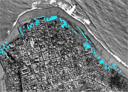
bati_residentiel_1950 a été numérisé par photo-interprétation, à partir de photographies aériennes de 1950 de l'IGN (téléchargées sur Géoportail et géoréférencées par le LIENSs). Cette donnée a été créée pour les 4 communes d'étude de la Réunion : Saint-Denis, le Port, Saint-Paul et Saint-Pierre. Cette donnée (créée aussi pour 1978) ne concerne que la frange côtière de ces communes (bande littorale d'environ 100 m de largeur).
-
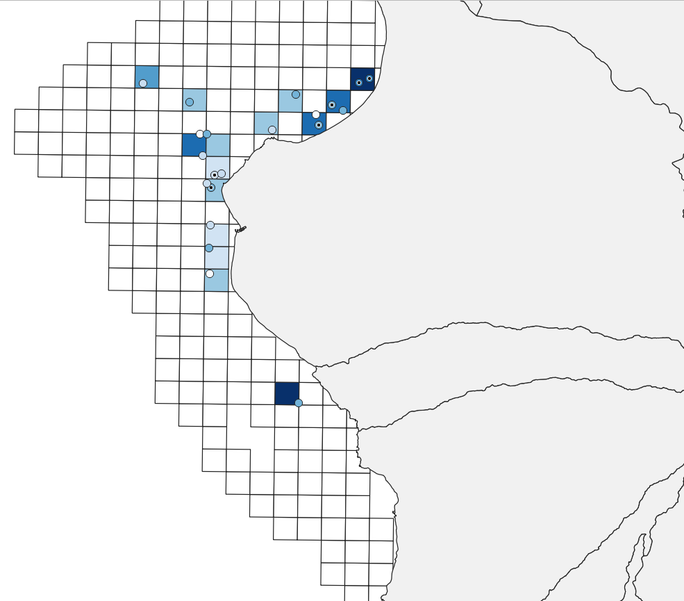
Entre 2017 et 2022, l’association Centre d’Etude et de Découverte des Tortues Marines (CEDTM) est en charge de mettre en œuvre une mesure de compensation de la Nouvelle Route du Littoral MCM05 intitulée "Amélioration des conditions de quiétude des mammifères marins et des tortues marines pour la durée du chantier" et financée par la Région Réunion. Dans le cadre de ce programme, des sorties régulières en bateau sont réalisées pour non seulement répertorier les observations des mammifères marins et tortues marines mais également pour sensibiliser les usagers de la mer. Ici deux couches par année d'observation sont disponibles, une couche point permettant de répertorier toutes les observations du Dauphin long bec (Stenella longirostris) ; une couches polygone, correspondant à un maillage de 1 km de côté et permettant de visualiser les observations du Dauphin long bec en fonction de l'effort d'échantillonnage.
-
Base de données des séismes à la Réunion
-
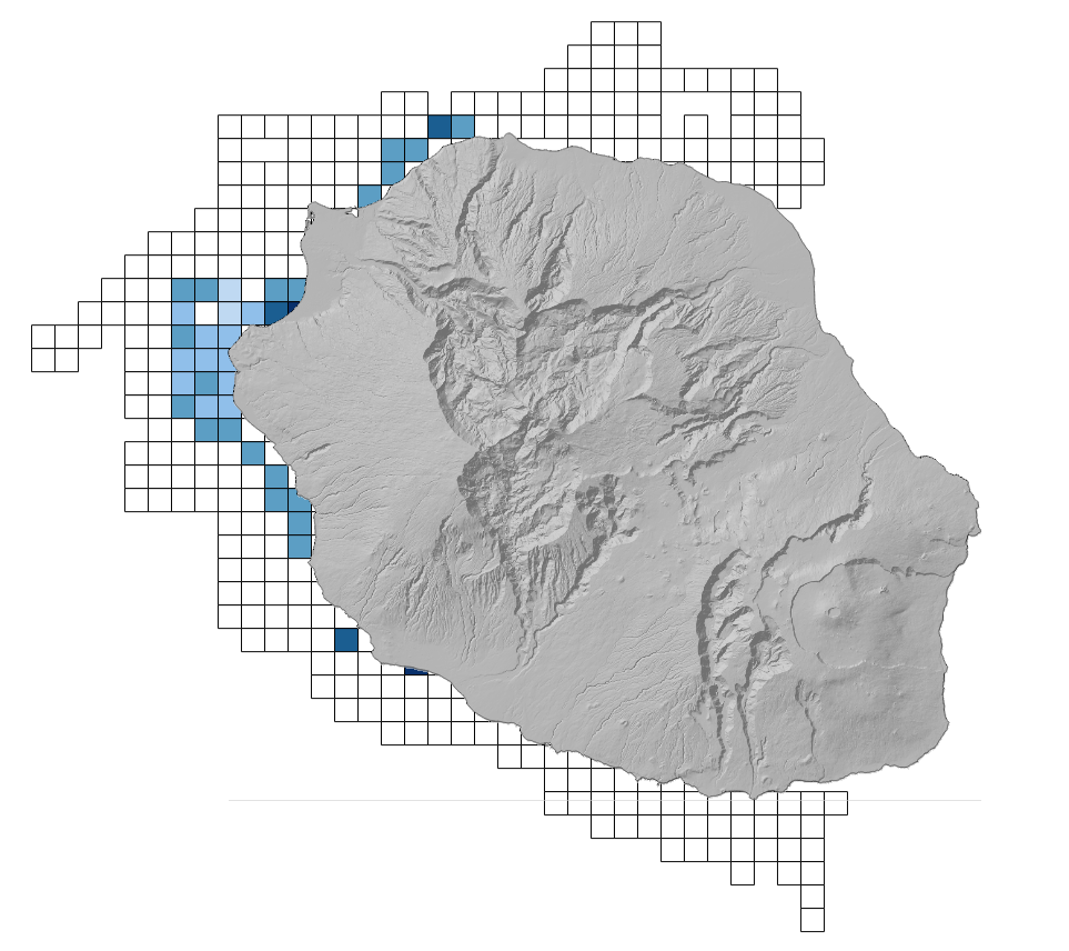
Cartographie des fréquences d'observation des différentes espèces de cétacés autour de l'île de La Réunion en 2016 selon une grille de maille 2kmx2km.
-
Le service permet de consulter sous forme cartographique les données d'observations issues des messages en code synoptique international d’observation en surface (SYNOP) circulant sur le système mondial de télécommunication (SMT) de l’Organisation météorologique mondiale (OMM). Paramètres atmosphériques mesurés (température, humidité, direction et force du vent, pression atmosphérique, hauteur de précipitations) ou observés (temps sensible, description des nuages, visibilité) depuis la surface terrestre. Selon instrumentation et spécificités locales, d'autres paramètres peuvent être disponibles (hauteur de neige, état du sol, etc.) Réunion - disponibles depuis les 5 derniers jours - fréquence 3h
-
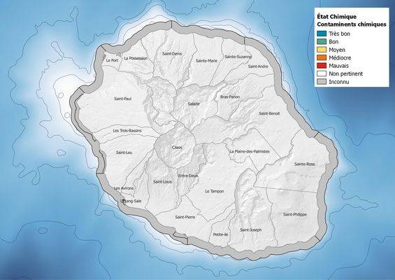
Évaluation de la qualité chimique des masses d’eau côtières de la Réunion dans le cadre du programme de surveillance de la Directive Cadre sur l'Eau (2000/60/CE). La fréquence du suivi est de deux fois par plan de gestion. Carte 2013 : la première campagne de suivi des contaminants chimiques étant prévue pour 2015, l'état des masses d’eau est noté en « inconnu ». L’évaluation la plus récente de l’état de cet élément est présentée dans l’atlas DCE Réunion.
-

Une masse d'eau plan d'eau est une partie distincte et significative des eaux de surface telles qu'un lac, un réservoir, constituant le découpage élémentaire des milieux aquatiques destinée à être l'unité d'évaluation de la DCE. Les masses d'eau plan d'eau sont dérivées du thème hydrographique BDCarthage® v3 de la BDCarto®. Correspondance rapportage DCE : cette entité correspond au concept de Lake Water Body (LWBODY) de WISE.
-
Série de données géographiques produites par le SIG Directive inondation pour le territoire de la Réunion et cartographiées aux fins de rapportage pour la directive européenne sur les inondations. La Directive européenne 2007/60/CE du 23 octobre 2007 relative à l'évaluation et à la gestion des risques d'inondation (JOUE L 288, 06-11-2007, p.27) influence la stratégie de prévention des inondations en Europe. Elle impose la production de plan de gestion des risques d’inondations qui vise à réduire les conséquences négatives des inondations sur la santé humaine, l’environnement, le patrimoine culturel et l’activité économique. Les objectifs et exigences de réalisation sont donnés par la loi du 12 juillet 2010 portant engagement national pour l’environnement (LENE) et le décret du 2 mars 2011. Dans ce cadre, l'objectif premier de la cartographie des surfaces inondables et des risques d'inondation pour les TRI est de contribuer, en homogénéisant et en objectivant la connaissance de l'exposition des enjeux aux inondations, à l’élaboration des plans de gestion des risques d’inondation (PGRI). Cette série de données sert à produire les cartes de surfaces inondables et la carte de risques d’inondation qui représentent respectivement les aléas d’inondation et les enjeux exposés à une échelle appropriée. Leur objectif est d’apporter des éléments quantitatifs permettant d’évaluer plus finement la vulnérabilité d’un territoire pour les trois niveaux de probabilité d’inondation (fort, moyen, faible).